
We all know it by another name, but Hull Tour Guide Paul Schofield reveals the surprising truth.
We all know it by another name, but Hull Tour Guide Paul Schofield reveals the surprising truth.

Our correspondent in Mr Chu’s, Angus Young, shares a personal memory of a great Hullensian, who is being laid to rest today.
Today more than 300 guests are expected to attend the funeral of Lord Prescott at Hull Minster. Family, friends and Labour Party colleagues will honour the life and legacy of a man who was not only the UK’s longest-serving deputy prime minister but also the MP for Hull East for a record-breaking 40 years. Having reported on politics in Hull for 30 years, I have many memories of him with the last time I saw him in political action sticking with me most.
It was a freezing cold January morning in 2018 and local VIPs had gathered in the refurbished former pumping station on Alexandra Dock for the official launch of Transport for the North’s new 30-year masterplan. As the speakers lined up on the stage a familiar figure appeared at the doorway.
“It’s a bloody fraud!” shouted Prescott from the back of the room. “It (TfN) was promised to have statutory powers. Now we know, and it’s been confirmed by the government, it will have no powers. It can’t make any decisions because it doesn’t get any money.” With that, he turned on his heels and stormed out leaving an awkward silence among the VIPs in his wake.
As was often the case, there was a touch of theatre about his brief appearance underlined by the fact he just happened to come across a BBC TV crew in the adjacent room giving him the opportunity to repeat his “bloody fraud” line for the cameras before storming off for a second time. Had it all been pre-arranged? Probably. Even if not, his criticism of a body conceived under successive Conservative governments made national headlines. Few could bash the Tories like Prescott.
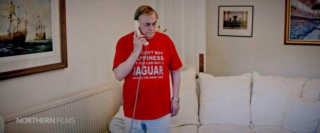
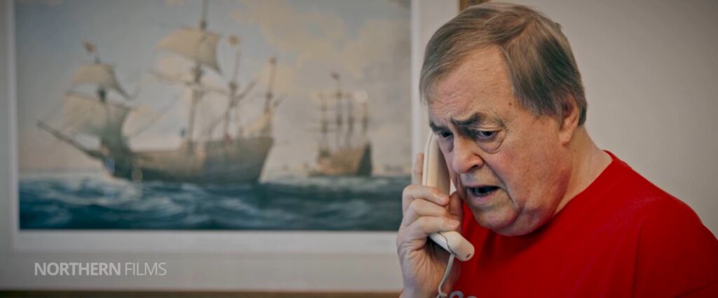
Following his death in November, he’s also set to make a posthumous appearance on the big screen by playing himself in a cameo role in The Last Trip, a feature-length comedy about five real-life retired Hull fishermen who steal a trawler for one final adventure at sea. In the scene, Lord Prescott pokes fun at himself by wearing a T-shirt with the logo: ‘You can’t buy happiness but you can buy a Jaguar which is the same thing’.
Northern Films director Andrew Fenton, whose own ex-trawlerman father stars as one of the crew members, said he hoped the film would also serve as a tribute to the late politician. He added: “At one point we were almost at the point of giving up on the film but John and Alan Johnson both gave us the encouragement to push on.
“When I told John about the idea for the film he just said: ‘Well lad, you better get on with it and don’t whisper about it down a well. Get on a bloody hill and yell about it. We need something like this for Hull. At that point, I suggested he could play himself and asked if he was in. He replied: ‘Of course I’m in. We remain extremely grateful to John and his wife Pauline who allowed us to film at their home in Hull to create a humorous cameo piece for the film.”
The Last Trip, starring John Prescott, will be released in cinemas later this Spring.

Chloe, a library assistant, gets right on song with some of the shows that get her toe tapping.

The Artistic Director of Humber Street Gallery, Marianne Lewsley-Stier, takes us inside one of the great seats of learning in the city.

An anonymous pupil from Griffin Park Primary asked this simple, yet complex, question.

Mark ‘Mak’ Page takes Burnsy behind the best gig of the year and reveals how everything Sesh works.

The Dapper Snapper George Norris returns to the spot where his pal Russell Boyce took a photo 40-odd years ago to see if anything is the same.

Dr Robb Robinson of the Uni of Hull takes us underground to uncover the man who proved the authorities wrong.

Our monument manoeuvre correspondent Angus Young tries to stay on the track of a tribute to a transient city dignitary.

By their very nature, statues are generally meant to stay put once they’ve been installed. But that’s not the case with a couple of landmarks in Hull.
William Wilberforce and his column’s shuffle across the city centre from Monument Bridge to overlook Queens Gardens during the 1930s is well-documented. Perhaps less known is the wanderlust associated with the statue of Andrew Marvell. In fact, if the 17th century poet, politician and possible spy were alive today and appearing on a TV reality show, he might well say: “I’ve been on a journey.”
Those travels began in 1867 when Councillor John Whinship presented his newly-commissioned sculpture to the Hull Corporation as a gift. Carved in white marble by Hull sculptor William Day Keyworth who would later commit suicide by shooting himself in the head, the statue originally stood inside the old Town Hall. However, shortly before Hull architect Cuthbert Brodrick’s beautiful Renaissance-style building was demolished to make way for the Guildhall we know today, it was decided to relocate the Marvell statue outdoors.

In 1902 the statue was moved from the shelter of the Town Hall to the centre of the junction of George Street and Savile Street in the city centre. Making it more accessible to the public probably seemed like a good idea at the time. What the city’s great and good didn’t foresee was the growth of the motor car.
Initially, the statue’s central berth allowed trams to pass by on either rise with room to spare. But when less predictable motor vehicles started to clog up the roads, it soon became a traffic hazard. As a result, in 1922 Marvell together with the square pedestal he was standing on was shifted around 50ft to one side of the road, safely out of the way of any wayward driver. For an unknown reason, the statue was also positioned facing a completely different direction. Instead of facing Jameson Street, Marvell was now looking directly at the Hull Savings Bank on the corner of George Street.

There he remained until 1963 when he was off once again with the proposed construction of a new dual carriageway which would eventually become Bond Street being the trigger. Once again, one of Hull’s most famous sons was getting in the way of traffic. This time Marvell put another three and a half miles on his clock before coming to rest near Bricknell Avenue at the site of Hull Grammar School which had moved there a decade earlier. As a former Grammar School pupil when it was based in Hull’s Old Town, the presence of a marble Marvell outside the main entrance was deemed to be a fitting nod to its past even the school building itself was relatively modern.
His stay in West Hull lasted until 1999 when he returned to the city centre to stand in the middle of Trinity Square as part of a facelift scheme for the public space. Even then, he wasn’t quite finished gadding about. Another revamp of the Square saw a cleaned-up Marvell later re-positioned once again, this time ending up closer to the original Grammar School building.
At the moment, he’s still there in what is his sixth location. Will he be moved again? Only time will tell.

The Bard of Holderness, poet Dean Wilson returns to tell us about his fondness for golden kings.