Altogether now ‘Forth, Tyne, Dogger, Fisher, German Bight, Humber…’ Our bedtime poetry correspondent Angus Young explores a favourite radio rhythm.
As many of its devoted fans already know, you don’t have to own a boat to enjoy The Shipping Forecast. Four times a day weather reports and forecasts for the seas around the British Isles are broadcast by BBC 4 on behalf of the Maritime and Coastguard Agency for the next 24 hours.
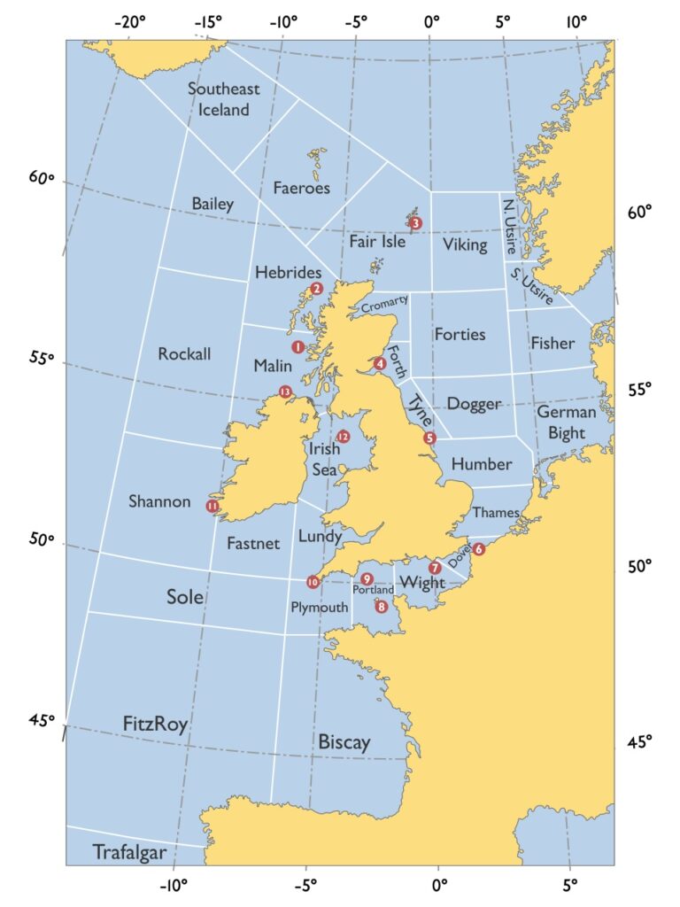
Produced by the Met Office, they cover a vast stretch of water divided into 31 areas including our very own Humber. Each broadcast features updated details of gale warnings currently in force, a general weather synopsis and specific sea area forecasts containing wind direction and force, weather and visibility.
The Humber weather area in The Shipping Forecast is very different from the estuary which flows into it. The grid-like map of all the areas show most of them as squares or oblongs and Humber is no different. As such, Humber’s coastal boundary stretches from just north of Flamborough Head to Horsey on the north-east corner of Norfolk. From this coastline it extends out into the North Sea and almost reaches the Netherlands.
It is officially listed as the Forecast’s 16th sea area and as each forecast follows the same order going clockwise around the British Isles, Humber is traditionally a midway point in the broadcast. This rigidly-applied chronology also typically means it’s sandwiched in between the Tyne and Dogger to the north, German Bight to the east and Thames and Dover to the south when areas are grouped together in the forecast. Because of variations in the weather, it’s rare to hear more than three areas named together.
Aficionados of the programme reckon six areas included in the same forecast is a show-stopping moment. A typical six-hander would read something like this: “Forth, Tyne, Dogger, Fisher, German Bight, Humber – West or south-west 7 to severe gale 9, occasionally storm 10 at first, except in Tyne and Humber. Very rough or high, but rough in Forth and Tyne. Squally showers.Good, occasionally poor.”
Jane Russell sailed the length of the Humber sea area recently and recorded her voyage for the Yachting Monthly magazine. She said: “The Humber sea area incorporates the interesting but more challenging coastlines of The Wash and North Norfolk as well as the Humber estuary itself. From the area’s northern boundary near Flamborough Head all the way to Norfolk, tidal flows become much more significant. The sea area is completely ruled by the currents that swirl around the between the banks and shoals that are the characteristic on this section of the East Coast. The extensive shoals are an extensive breeding ground for windfarms which, depending on your perspective, can either confuse or clarify navigation.”
Last year’s 125th anniversary of the first spoken word BBC radio broadcast of the Forecast was marked by a series of special programmes celebrating what has become a British institution, having originally been established in 1861 as a warning service to shipping using telegraph communications and later radio transmission via the Met Office.
Today many land-dwelling listeners tune in just for its rhythmic poetic quality rather than any precise information about weather conditions at sea, delighting in the precise but reassuring terminology and the roll-call of distant, storm-lashed sea areas. As Catherine Croft, director of the Twentieth Century Society, puts it: “It’s a poetic reverie and a symbol of national caring, whilst at the same time a reminder of our geographical isolation and the uncontrollable power of natural phenomena.”