
Sounds like a bit of a conspiracy theory, but our fortified waterways correspondent Angus Young thinks the truth is literally beneath us.

For most of its 33-mile length, the River Hull gently winds its way through East Yorkshire and the northern suburbs of Hull. Like any natural watercourse, it twists and meanders according to the local terrain and the speed of the flowing water. But the river’s final stretch from High Flags where Scott Street bridge once stood to the Humber is very different. Apart from a hardly noticeable kink near Drypool Bridge, it’s uncannily straight.
The river’s last leg could be encased in plaster such is the curve-free line it follows all the way to The Deep. However, the river once took a very different route. Historians think severe flooding in the River Hull valley in 1253 not only inundated much of the marshland north of the Humber but also diverted the course of the river into another watercourse called Sayer Creek.
The creek was a man-made channel originally dug to drain land to the east but thanks to the flood became the new course of the river from High Flags that we know today. So where did the river flow before that?
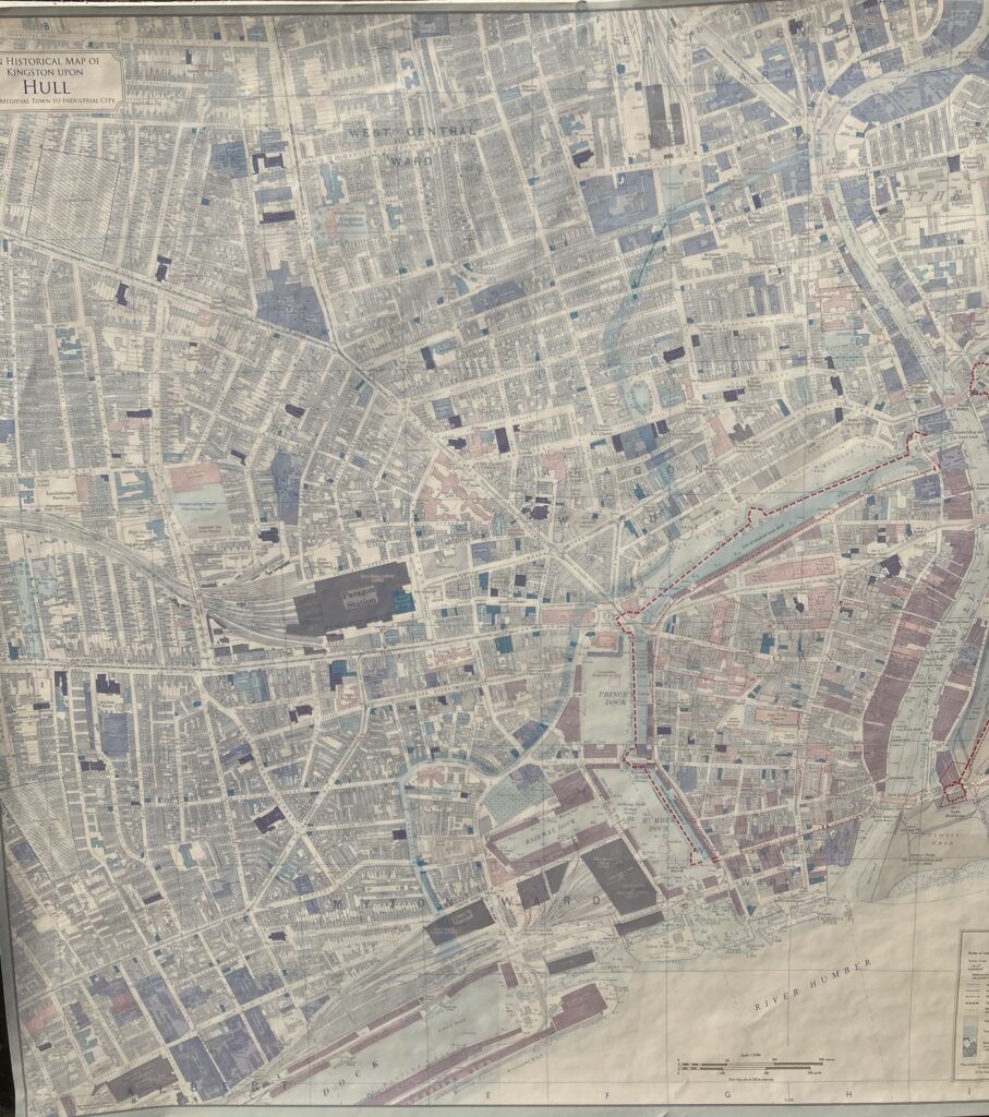
The ancient route can be traced on a recently-published map of Hull showing locations of buildings and landmarks in 1928 with the river’s final winding stretch superimposed on top. You can find a copy in the map section of the Hull History Centre. However, you can also walk along the route through various city centre streets imagining that you’re actually taking a stroll on an ancient riverbank. In fact, once you realise the old riverbed is actually somewhere deep under your feet you begin to recognise the faint but tell-tale low-lying nature of the ground around you.
Starting just north of Scott Street, the old river headed south at what is now Caroline Street before crossing Freetown Way and flowing through the area currently occupied by Kingston Square. From there it flowed south under where the Maltings Business Park stands today and across George Street before meandering close to the Hull Maritime Museum, going under Hull City Hall and running along the route of Waterhouse Lane.
A significant bend in the old river then occurs roughly where the Mytongate junction on the A63 at Castle Street is today, close to the spot where the new road tunnel is being constructed. Interestingly, the 1928 map shows the bend in the river corresponding almost exactly to the crescent-shaped Great Passage Street which no longer exists. The street was an ancient highway which is recorded as far back as the 12th century. As such, it was almost certainly originally adjacent to the river and is thought to have been the location of the hamlet of Myton.

In the 17th and 18th centuries it reverted back to being little more than a track to a couple of scattered properties as the town of Hull developed to the east but in the 19th century a neighbourhood was re-established as Hull expanded to the west. The street itself disappeared when the Mytongate roundabout was built in the late 1970s.
The final stretch of the old river runs south adjoining what is now the Kingston Retail Park before reaching Albert Dock and joining the estuary. Had the great flood of 1253 not happened, the confluence of the River Hull might still be there along with The Deep and the Tidal Barrier and not where it eventually ended up half a mile away.
Angus Young