East is south and up is down on the new bus map of the city, but as our cartography orientation correspondent Angus Young reports, it’s happened before.
Hull’s cartographic history is almost as compelling as the maps themselves. There’s even a specially-written booklet about the subject and an accompanying folder containing a dozen carefully-selected reproduction maps through the ages. Published in 1973, it cost just £1 from local libraries and is now something of a collector’s item.
The maps in the booklet include an undated plan of the town thought to have been drawn in Elizabethan times showing how Hull might have looked in 1350 and even includes brief biographies of some of the most celebrated cartographers. Also featured in the booklet is perhaps the best known map of Hull.
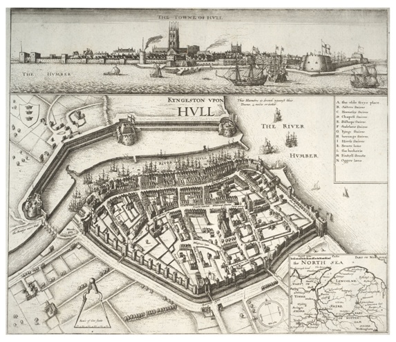
Dating from 1640, it’s the work of Prague-born artist and engraver Wenceslaus Holler who created a bird’s eye view of Hull looking from the west across the town to the River Hull and the Citadel military defences beyond. Holler’s detailed decorative work shows many still recognisable streets squeezed within the town walls just before the outbreak of the English Civil War.
It’s the map’s unusual eastwards perspective which initially grabs the attention, though, and he includes a compass in the bottom right corner to help the viewer get their bearings. Why Holler chose this angle remains a mystery as nearly every other map of Hull, both before and since, depicts a more conventional view looking north with the Humber estuary as the southern boundary.

However, 385 years later, a new map of Hull is prompting double-takes across the city in probably much the same way as Holler’s did when he completed it. Whereas his map is thought to have been commissioned by his patron the Earl of Arundel, this new lop-sided view of Hull is a more humble affair and adorns bus shelters across the city courtesy of the council.
At first glance, the Hull Citywide Bus Map just doesn’t look right. The Humber estuary lies to the left-hand side of the map in what would normally be assumed to be the east on a map instead of occupying its traditional southern spot on the bottom. Confused? Not half as those living in West Hull which is at the top of the map and those in East Hull lurking at the bottom. Spare a thought for North Hull residents as their area isn’t name-checked at all.
Like Hollar’s map there’s a compass in the bottom right corner which serves the same purpose as his all those years ago for those still bewildered by the layout. Perhaps this is actually a tiny clue. Maybe the map has been drawn by a secret Holler fan because I can’t think of another explanation why someone would want to mess with the conventional view of Hull in this fashion.
Eventually, it all makes sense if you get your head around the fact it’s looking at Hull from the east as Curiosity’s favourite poet Dean Wilson might see it from the top deck of a bus on a day trip from Withernsea to Hull.