And no, it’s got nothing to do with Ray Davies or knicker shops, says our warped highways correspondent Angus Young.

Before we start answering today’s Curiosity question, let’s clear up a few things. Today’s instalment has got nothing to do with rumours about dedicated follower of fashion Ray Davies getting his old band back together for a comeback gig in Hull. Nor is it a prelude to the legendary Gwenap shop re-opening in a new location any time soon. Instead, we’re talking about a physical feature of Beverley Road you’ve probably never noticed before.
Like most of Hull’s long arterial routes, Beverley Road runs pretty much straight as an arrow. It’s also very old. After King Edward I issued a royal charter to found Kingston upon Hull in 1293, work started on creation of a number of permanent roads to neighbouring towns. Among them was a road to and from Beverley. By 1305 it was largely completed and was 60ft wide in some sections.
The next important date in the route’s history is 1714 when a private act of parliament was passed to turn it into Yorkshire’s first ever turnpike with travellers paying tolls to use it. Tolls were collected at the junction of Cottingham Road and the Beverley Gate entrance to the town itself.
Although flanked by open farmland, sporadic development gradually took place along the route with the small hamlet of Stepney being the most notable. By the late 18th century it boasted a number of scattered farmsteads, a couple of pubs and a Methodist Church.
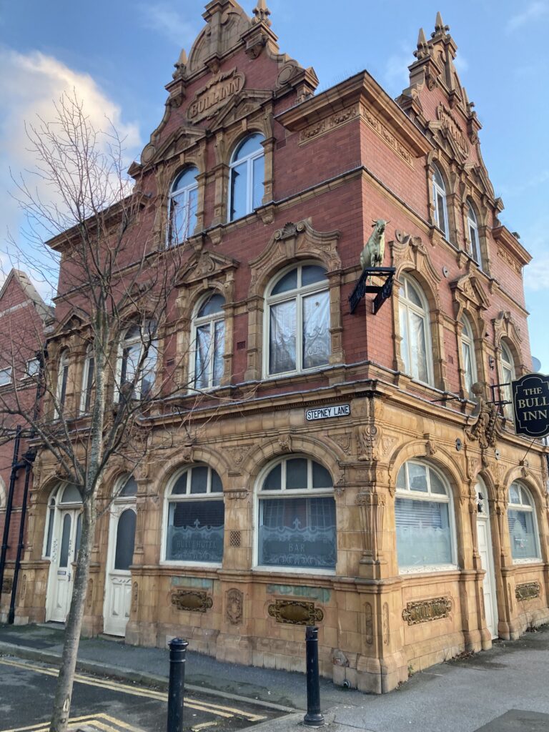
The old hamlet was effectively wiped off the map during mid to late 19th century Victorian development which effectively replaced it. The oldest surviving buildings from that period are the former Stepney railway station house and the Pentecostal Glad Tidings Hall at the junction with Cave Street. The old Stepney stretched from just south of the railway (which was opened in 1848) to where two former pubs – the Rose Hotel and The Bull Hotel – now stand opposite each other.
It’s here where the main road gently curves westwards away from its otherwise straight path before returning to normal just after the entrance to Pearson Park. The kink is barely noticeable if you’re driving but take a slow walk around the spot, look at the layout of the buildings and – with a bit of imagination – you can visualise the northern boundary of where the old village was being modestly redeveloped with shops and terraced streets..

The Rose and the Bull act as bookends with Stepney Lane (once a footpath) the dividing line between Stepney and a newer district of grand detached Victorian villas and prestigious public buildings, including Beverley Road Baths and Stepney Primary School. The origin of the curve is almost certainly due to the position of the villas and the requirement to provide their well-heeled residents with expansive, sweeping views looking across the widened tree-lined road towards the Baths and the School. As ever, money talked and the kink was constructed to make things pleasing on the eye for all concerned, especially the posher ones.
Back then, it must have felt like walking from a working-class area into a comfortable upper middle-class neighbourhood in just a couple of steps. Today, you can still sense the change from the densely-packed ribbon of shops lining Beverley Road as it cuts through Stepney to the spacious urban vistas beyond.
Sadly, both the Rose or the Bull are no longer pubs, having been converted into flats. Happily, both their distinctive architecture and distinctive old pub signage remain largely intact – including the famously Norman Collier-esque noticeboard outside The Rose which continues to delight passers-by of a certain age.