
Author and aging Britpopper Nick Quantrill goes the Whole Wide World to end up on a (probably) different bench to Eric Goulden.
Author and aging Britpopper Nick Quantrill goes the Whole Wide World to end up on a (probably) different bench to Eric Goulden.

Bex is the general manager at Artlink and a movie fan. Here are her five favourite flicks.

The East bank of the river has long been a mess, but now you have your chance to say how it’s put right, reports our dilapidated riverside correspondent Angus Young.

Most of the eastern side of the River Hull between Drypool Bridge and Myton Bridge has been an eyesore for years. Vacant land and empty buildings form an almost continuous view. However, things are about to change.
Plans are currently being drawn up to build around 850 new waterfront homes there together with ground floor commercial units alongside two public parks, plazas and a riverside walkway. Two existing derelict buildings – the former Trinity House buoy shed and the adjacent lock keeper’s cottage last used as part of an emergency night shelter for the homeless – are expected to be refurbished and retained as part of the new development. Being Hull, it’s not going to happen overnight.
At the moment, it’s envisaged that building work will be phased over four stages with the first construction expected to start in 2027. However, the East Bank Urban Village has the potential to not only breathe new life into the immediate area but also bring some much-needed quality modern residential design into the city centre on a scale not really seen since the re-development of Victoria Dock in the early 1990s.

The plans are at an early stage but the development partners – Hull City Council and ECF (a public-private regeneration and investment partnership which includes Homes England, Legal & General and developer Muse – have signed on a joint deal to deliver the scheme over the next 15 years.
As a first step, they have launched a public consultation to see what people think of their initial concept designs and ideas for the site. There’s an online questionnaire to complete at www.eastbank-hull.com and an exhibition being staged at Trinity Market on Thursday, October 2, between 4pm and 8pm. As well as the concept designs, visitors to the exhibition will be able to chat with representatives from the partnership and give their own views on the project.

Cllr Paul Drake-Davis, portfolio holder for economic renewal, housing and organisational development at the council, said: “East Bank Urban Village is one of Hull’s largest ever regeneration projects and will act as a catalyst for further urban renewal and help to increase investor confidence in the city with all the economic benefits that will arise. The development is the future of Hull’s city centre living and so it’s important that our residents and other stakeholders and interested parties share their thoughts to help shape it.”
Raife Gale, senior development manager at ECF, said: “This is a project that will have a hugely positive impact on Hull, delivering much needed new homes in the heart of the city centre while breathing new life into a site with a rich heritage and maritime past. We want to ensure the local community are involved in shaping what our plans look like, so we are looking forward to working closely with them as we progress the first stage of this important new development.”
So get yourself along to Trinity Market and have your say or fill in the questionnaire. The deadline for online comments is Wednesday, October 8.

Ex top politician turned novelist Alan Johnson takes a trip back to a familiar and undeniably gorgeous thoroughfare.

We bumped into Hull band Empty Banner at the Humber Street Sesh and they counted down the tunes they wish were there’s.

We’ve all enjoyed a proper soaking and a scare in it, but Hull Tour Guide Paul Schofield explains why the greatest thrill ride in Hull exists.

We’ve all heard of places like Gipsyville and Bransholme but, as our revived suburb correspondent Angus Young reports, Thistleton may yet be equally well-known.
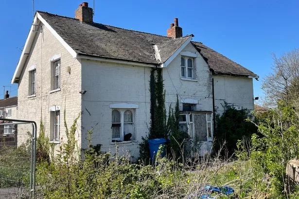
A side street off Stoneferry Road might seem like an unlikely place to revive a lost piece of Hull’s history. But that’s exactly what is currently happening in Woodhall Street. Where the terraced street ends and becomes a narrow footpath which crosses a cycle route is the kind of building project you might see on Kevin McCloud’s long-running TV show Grand Designs.
Two years ago a dilapidated detached property overlooking the footpath had become both an eyesore and an occasional refuge for squatters. Once a farm cottage next to Fordyke Drain and surrounded by open countryside, it had been earmarked for demolition as part of approved plans to build three new homes on the site. But when the owner changed his mind and decided to sell instead, self-employed builder Jason Copping stepped in to buy it.
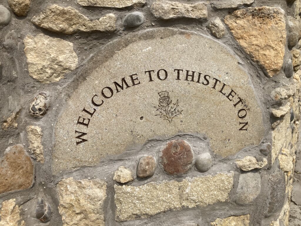
As part of his ongoing restoration, the area’s historic name of Thistleton has been revived. It’s not clear where the name came from or exactly when but an advert in the Hull Packet newspaper dated June 1808 records the proposed sale by auction of a “new-built dwelling house consisting of six small rooms, pleasantly situated in Thistleton, about half way on the foot-road from Hull to Sutton.” According to the advert, the new property formed one of a row of houses “built and intended to be continued in perfect uniformity and commanding a fine view of Hull, the Humber, etc, together with a garden in front of the house.”
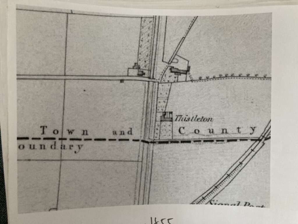
Whether it’s the same property is hard to tell but an Ordnance Survey map from 1855 features five buildings relatively close together. Collectively, they are referred to as Thistleton with Thistleton Farm as the main property.

Despite Thistleton appearing on old maps, it was only ever a small hamlet rather than a bigger village in its own right such as Marfleet or Sutton. Dairy farming and market gardening are both recorded at Thistleton in the 19th century but by 1907 the area’s agricultural era came to an end when most of the land was acquired by Reckiits as part of the company’s industrial expansion in East Hull. It’s likely the aforementioned terrace of four cottages disappeared around this time along with the Thistleton name, making way for a recreation ground for employees at the Reckitts factory.
Establishing the age of the surviving building now being refurbished has been difficult, not least because of the discovery of two large pieces of thick slate which had formed part of a fireplace surround. Both feature the hand-etched date “1762”. However, it’s thought they could have been taken from another older building for use during the cottage’s construction as recycling materials from other properties was quite common back in the day.
Despite its age and being one of an historic agricultural kind in Hull, the cottage is not designated as an official listed building. As such, the current upgrade mixed the traditional with some more unusual quirks. The hallway features stained glass from a former chapel in Grimsby while the impressive wrought iron entrance gates were once part of a farm in Driffield.
The Thistleton name is also now immortalised on an old millstone set into a new boundary wall, having been engraved by Hessle Road-based monumental mason David Phillips.
Angus Young

Curiosity’s own location scout Joe Sargieson goes in search of the places Steve McQueen (not that one) made his WW2 epic.

Author and illustrator Ramzee picks his best reads from 2025 so far.

As it’s currently Heritage Open Days time, we got our ancient rock Angus Young to chip in with some pieces of history anyone can visit.

They’re not part of any official tourist trail around Hull’s Old Town. Nor do they feature in Hull City Council’s register of non-listed buildings or structures regarded as being of local historic interest – a tier below Historic England’s national listing system. Instead, three large hand-carved stones dating back to the late 1700s remain largely overlooked despite the fascinating story they tell. So here’s an opportunity to see them for yourself the next time you visit the Old Town as we take you on a tour of some of the area’s most unusual physical landmarks.
We start in Chapel Lane. Head along the historic route from Lowgate towards High Street and you will see a car park on an open patch of land on your right just after Standidge Buildings. A rather splendid old brick wall separates the car park from the warehouse and if you get up close to the wall you will see a large rectangular stone standing on top of it. Inch a bit closer and you can just about make out the faded words carved onto the stone. They read:“A Party Wall from North to South 60 feet.”

The first significant legislation requiring party walls to be constructed between neighbouring buildings was triggered by the Great Fire of London in 1666. Under the new law, party walls had to be sturdy enough to withstand two hours of fire, giving people the chance to escape while also providing a greater opportunity to extinguish the blaze. The legislation helped turn wooden towns and cities into brick ones.

In Hull, bricks had long played an important part in the town’s built history as natural stone was relatively scarce locally and had to be imported at considerable expense. As such, the party wall stone in Chapel Lane would have been a significant acquisition as well as identifying an important newly-built safety feature in the street. Records of businesses based there suggest it was constructed between a brewery and a bakery and could well be the work of stonemason Daniel Hopewell who owned a yard in the late 18th century.

The second stone on our tour can be seen in Scale Lane. Walk up the lane from Lowgate towards the pedestrian bridge over the River Hull and look to your left at Bayles House, first documented in 1751 as a wealthy oil merchant’s house set back from High Street. Originally set within an inner courtyard, the party wall stone is now set on a gable end overlooking the lane. Natural erosion makes it hard to read but my take is: “A Party Wall 44 Feet 7 Inches Length By 2 Feet Width”.
This stone is much smaller than the one in Chapel Lane but the third is probably the largest of them all. Sadly, weather damage has obliterated the wording but its impressive size indicates the importance of the wall it sits on – the boundary between the original Trippett Street burial ground of St. Mary’s Church and the Charterhouse Maister’s House. The land was consecrated as a burial ground in 1775 and the house was built five years later so the dates fit with the other stones, suggesting a contemporary trend in Hull for physically recording the dimension of boundaries for use in potential future land ownership deals or disputes.
They might not boast the architectural beauty of an ancient church or a civic building but, for me at least, these old stones are just as fascinating for the stories they tell about Hull and its history.