
With Hull Fair weather starting to kick in, Andy Train of Pride In Hull takes a stroll to the place where it all happens.
With Hull Fair weather starting to kick in, Andy Train of Pride In Hull takes a stroll to the place where it all happens.

Librarian Lewis from Fred Moore Library runs down his pick of the players from the Premiership and beyond.

How do you coax your kids to get their hands dirty and commune with nature? The answer may lie just off Holderness Road.

Our spherical sculptures correspondent Angus Young talks council plans, litter and balls. (As usual.)
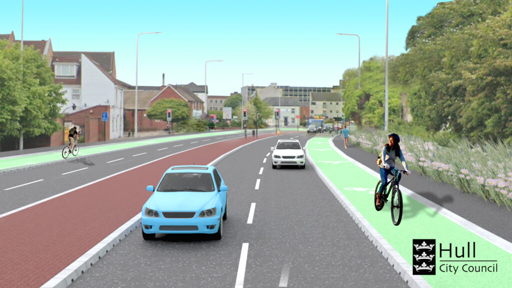
Big changes are about to happen on Freetown Way in Hull city centre. Subject to a contractor being appointed, work to restore two lanes of vehicle traffic in each direction along the dual carriageway is scheduled to start before the end of the year. In addition, footways will be widened on either side to accommodate separate off-road cycle routes. When all of this happens I hope an often overlooked feature of the original road scheme is retained.
The proposed route of the new dual carriageway was first mapped out in the 1970s, slicing through a mainly residential area. Until it opened to traffic in 1986, it was known as the North Orbital Road. It formed part of a larger orbital route circling the city centre which also included the new South Orbital Road (later to become simply known as Castle Street) and Great Union Street.

The South Orbital Trading Park and the Orbital Garage in Raven Street are reminders of those sphere-shaped days of transport planning in the city even though, on paper, the orbital route actually looks more like a rectangular box.
Eventually, like its southern namesake, the North Orbital Road became known as something else when it was named after Hull’s twin town in Sierra Leone. To cement this link, Sierra Leone’s High Commissioner Victor Sumner performed the official opening ceremony alongside Hull’s Lord Mayor Alf Bowd. However, the icing on the circular cake was yet to come.
When Welton-based artist Jacqueline Steiger was commissioned to create a new artwork to commemorate the opening of the new dual carriageway she naturally went with the flow. Simply known as Orb, her giant sculptured bronze sphere sits on a rising mound of concrete covered in cream-coloured tiles. Standing next to the junction with Percy Street, it reminds me of the spaceship appearing dramatically above the mountain in Close Encounters of the Third Kind. Steiger herself describes it as “a huge, eye-level punctuation mark which takes your eye away from its surroundings”.
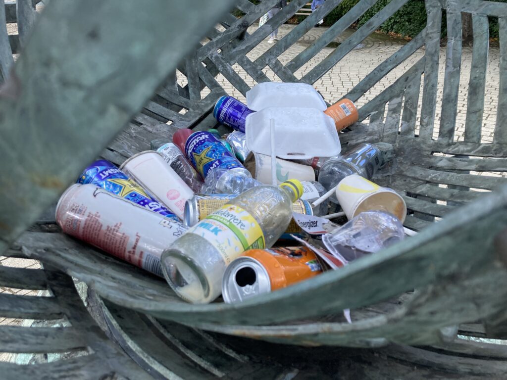
Her design was intended to allow people to both see into the globe and through it. What she probably didn’t anticipate was this also provides the perfect opportunity for passers-by to dump their rubbish in it. On my most recent visit, I spotted a pile of discarded cans, plastic bottles and a fast food box nestling within its base.
Despite the litter, Orb is still an impressive piece of work and I just hope it survives the looming makeover. A few replacement tiles to fill the gaps left by nearby missing ones certainly wouldn’t go amiss either. Perhaps another sculpture might be commissioned to stand in the middle of one of the other currently empty circular rings of stone tiles which are a feature of the junction
Orb 2, anyone?

Dr Robb Robinson of the Uni of Hull tells a tale of the high seas, adventure and tragedy.

Ace author Simon James Green chances his arm on our quiz with quizmaster Ally-mai at the Big Malarkey.

The very first publicly-owned pub in the city has recently opened and so Burnsy gets the lowdown during a lock-in with landlord Jamie Reading.

East is south and up is down on the new bus map of the city, but as our cartography orientation correspondent Angus Young reports, it’s happened before.
Hull’s cartographic history is almost as compelling as the maps themselves. There’s even a specially-written booklet about the subject and an accompanying folder containing a dozen carefully-selected reproduction maps through the ages. Published in 1973, it cost just £1 from local libraries and is now something of a collector’s item.
The maps in the booklet include an undated plan of the town thought to have been drawn in Elizabethan times showing how Hull might have looked in 1350 and even includes brief biographies of some of the most celebrated cartographers. Also featured in the booklet is perhaps the best known map of Hull.
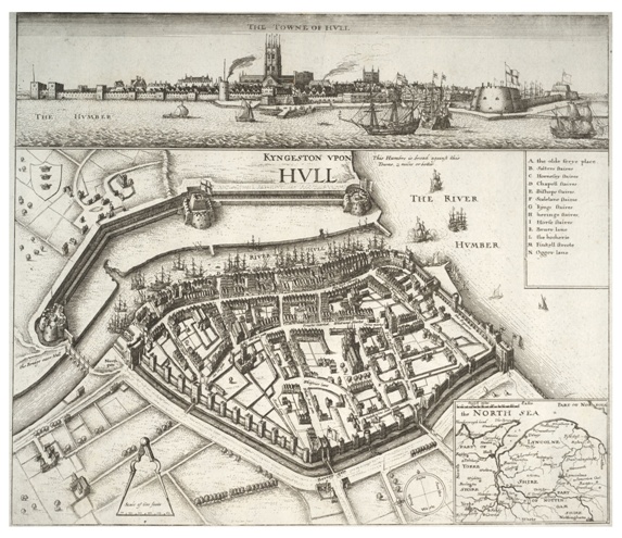
Dating from 1640, it’s the work of Prague-born artist and engraver Wenceslaus Holler who created a bird’s eye view of Hull looking from the west across the town to the River Hull and the Citadel military defences beyond. Holler’s detailed decorative work shows many still recognisable streets squeezed within the town walls just before the outbreak of the English Civil War.
It’s the map’s unusual eastwards perspective which initially grabs the attention, though, and he includes a compass in the bottom right corner to help the viewer get their bearings. Why Holler chose this angle remains a mystery as nearly every other map of Hull, both before and since, depicts a more conventional view looking north with the Humber estuary as the southern boundary.

However, 385 years later, a new map of Hull is prompting double-takes across the city in probably much the same way as Holler’s did when he completed it. Whereas his map is thought to have been commissioned by his patron the Earl of Arundel, this new lop-sided view of Hull is a more humble affair and adorns bus shelters across the city courtesy of the council.
At first glance, the Hull Citywide Bus Map just doesn’t look right. The Humber estuary lies to the left-hand side of the map in what would normally be assumed to be the east on a map instead of occupying its traditional southern spot on the bottom. Confused? Not half as those living in West Hull which is at the top of the map and those in East Hull lurking at the bottom. Spare a thought for North Hull residents as their area isn’t name-checked at all.
Like Hollar’s map there’s a compass in the bottom right corner which serves the same purpose as his all those years ago for those still bewildered by the layout. Perhaps this is actually a tiny clue. Maybe the map has been drawn by a secret Holler fan because I can’t think of another explanation why someone would want to mess with the conventional view of Hull in this fashion.
Eventually, it all makes sense if you get your head around the fact it’s looking at Hull from the east as Curiosity’s favourite poet Dean Wilson might see it from the top deck of a bus on a day trip from Withernsea to Hull.

Chair of the Hull Fishing Heritage Centre Jerry Thompson runs down the people who mean the most to him from his days at sea.

Top architect Jonathan Smith explains why he finds inspiration in one of the most familiar buildings in the city.