Which Hull Street Is Associated With England’s Fattest Vicar?

Our stout clergyman correspondent Angus Young gets perilously close to fat-shaming in this cautionary tale of street names and scale busting.

The Coltman’s Land stone, yesterday.

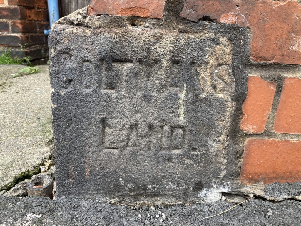
Blink and you might miss a small rectangular stone which forms part of one of two brick pillars outside a property where King’s Bench Street meets Saner Street. Encrusted in decades worth of grime, it’s believed to be only surviving one of its kind in Hull. The stone’s precise age is unclear but the reason why it was laid there in the first place can just about be seen through the muck. Carved into the stone are two words – Coltman’s Land – which confirm it was once a visual marker for the boundary of land owned by the Coltman family.

Before its acquisition by the Coltman dynasty, much of the pastureland which made up Myton Carr had been owned by the family of John Lister, a wealthy merchant and politician who, like his father, served as both Mayor and MP for Hull in the 17th century. After Lister’s death in 1640, his estate was passed down the family lineage until land and a substantial dwelling on Myton Carr to the immediate west of Hull was bequeathed to Joseph Coltman by an aunt..

The undeniably portly Rev. Jospeh Coltman.

Joseph was literally the larger-than-life vicar of Beverley Minster as he weighed just over 37 stones and, at the time, was known as England’s heaviest man. The eldest of seven children, Joseph was born in Hull in 1776 and lived in the town until he was ten when his parents moved to Beverley.

A year later he started his formal education at Charterhouse School in London and completed it by graduating from Trinity College in Cambridge. After being ordained as a priest, he was appointed rector of a church in Lincolnshire where his father, who was a wealthy merchant in Hull, also owned land.

Joseph returned to Beverley in 1806 when he was appointed assistant curate at the Minster and he would remain in the town for the rest of his life, becoming a respected part of both its clerical and civic life. However, his enormous size and the stories it inspired eclipsed all this.

Most famously, he was known to use a two-wheel dandy-horse to get around with a servant pulling him along with a rope. At his vicarage, doorways were widened and floors strengthened while several church officials were always on hand to help him into the pulpit before he took a service.

Joseph died in tragic circumstances in 1837, turning over in bed and suffocating with his face in a pillow being unable to move because of his weight. His servants – he had six- were blamed by some as they were meant to help him shift his sleeping position at night. After his funeral service, his body was lowered into the grave with a block and tackle used for lifting heavy masonry at the Minster.

The bend in Coltman Street, yesterday.

Joseph’s death meant his land and property in Hull passed to his brother Thomas, who was a judge based in London. He decided it would be more profitable to turn the fields and meadows into streets as Hull’s population was expanding rapidly. The family name was given to Coltman Street which was developed in the 1840s. The noticeable bend in the street at the Anlaby Road end is actually where the ancient field boundaries of Myton Carr converged. This ancient boundary line also runs through to Saner Street where the ownership stone still stands.

Other echoes from those days remain in the names of King’s Bench Street and Queensgate Street – two Coltman family addresses in London, while Bachelor Street takes its name from a family into which the Coltmans married.

As for Saner Street, it stands across the border from Coltman’s Land and was named after  John Saner, another wealthy landowner who was also a magistrate and director of the Hull Dock Company.

Angus Young

What’s Happening With The Derelict Land Next To The River Hull?

The East bank of the river has long been a mess, but now you have your chance to say how it’s put right, reports our dilapidated riverside correspondent Angus Young.

The East side of theRiver Hull, yesterday. (Pic Jacquie Baron)

Most of the eastern side of the River Hull between Drypool Bridge and Myton Bridge has been an eyesore for years. Vacant land and empty buildings form an almost continuous view. However, things are about to change.

Plans are currently being drawn up to build around 850 new waterfront homes there together with ground floor commercial units alongside two public parks, plazas and a riverside walkway. Two existing derelict buildings – the former Trinity House buoy shed and the adjacent lock keeper’s cottage last used as part of an emergency night shelter for the homeless – are expected to be refurbished and retained as part of the new development. Being Hull, it’s not going to happen overnight.

At the moment, it’s envisaged that building work will be phased over four stages with the first construction expected to start in 2027. However, the East Bank Urban Village has the potential to not only breathe new life into the immediate area but also bring some much-needed quality modern residential design into the city centre on a scale not really seen since the re-development of Victoria Dock in the early 1990s.

An artists impression of plans.

The plans are at an early stage but the development partners – Hull City Council and ECF (a public-private regeneration and investment partnership which includes Homes England, Legal & General and developer Muse –  have signed on a joint deal to deliver the scheme over the next 15 years.

As a first step, they have launched a public consultation to see what people think of their initial concept designs and ideas for the site. There’s an online questionnaire to complete at www.eastbank-hull.com and an exhibition being staged at Trinity Market on Thursday, October 2, between 4pm and 8pm. As well as the concept designs, visitors to the exhibition will be able to chat with representatives from the partnership and give their own views on the project.

Another artists impression of plans.

Cllr Paul Drake-Davis, portfolio holder for economic renewal, housing and organisational development at the council, said: “East Bank Urban Village is one of Hull’s largest ever regeneration projects and will act as a catalyst for further urban renewal and help to increase investor confidence in the city with all the economic benefits that will arise. The development is the future of Hull’s city centre living and so it’s important that our residents and other stakeholders and interested parties share their thoughts to help shape it.”

Raife Gale, senior development manager at ECF, said: “This is a project that will have a hugely positive impact on Hull, delivering much needed new homes in the heart of the city centre while breathing new life into a site with a rich heritage and maritime past. We want to ensure the local community are involved in shaping what our plans look like, so we are looking forward to working closely with them as we progress the first stage of this important new development.”

So get yourself along to Trinity Market and have your say or fill in the questionnaire. The deadline for online comments is Wednesday, October 8.

Angus Young

Why Is A Forgotten Place Name In Hull Being Brought Back To Life?

We’ve all heard of places like Gipsyville and Bransholme but, as our revived suburb correspondent Angus Young reports, Thistleton may yet be equally well-known.

An old map of Hull, yesteryear.

A side street off Stoneferry Road might seem like an unlikely place to revive a lost piece of Hull’s history. But that’s exactly what is currently happening in Woodhall Street. Where the terraced street ends and becomes a narrow footpath which crosses a cycle route is the kind of building project you might see on Kevin McCloud’s long-running TV show Grand Designs.

Two years ago a dilapidated detached property overlooking the footpath had become both an eyesore and an occasional refuge for squatters. Once a farm cottage next to Fordyke Drain and surrounded by open countryside, it had been earmarked for demolition as part of approved plans to build three new homes on the site. But when the owner changed his mind and decided to sell instead, self-employed builder Jason Copping stepped in to buy it.

A house in Thistleton, before renovation.

As part of his ongoing restoration, the area’s historic name of Thistleton has been revived. It’s not clear where the name came from or exactly when but an advert in the Hull Packet newspaper dated June 1808 records the proposed sale by auction of a “new-built dwelling house consisting of six small rooms, pleasantly situated in Thistleton, about half way on the foot-road from Hull to Sutton.” According to the advert, the new property formed one of a row of houses “built and intended to be continued in perfect uniformity and commanding a fine view of Hull, the Humber, etc, together with a garden in front of the house.”

Whether it’s the same property is hard to tell but an Ordnance Survey map from 1855 features five buildings relatively close together. Collectively, they are referred to as Thistleton with Thistleton Farm as the main property.

A house in Thistleton, during renovation.

Despite Thistleton appearing on old maps, it was only ever a small hamlet rather than a bigger village in its own right such as Marfleet or Sutton. Dairy farming and market gardening are both recorded at Thistleton in the 19th century but by 1907 the area’s agricultural era came to an end when most of the land was acquired by Reckiits as part of the company’s industrial expansion in East Hull. It’s likely the aforementioned terrace of four cottages disappeared around this time along with the Thistleton name, making way for a recreation ground for employees at the Reckitts factory.

Establishing the age of the surviving building now being refurbished has been difficult, not least because of the discovery of two large pieces of thick slate which had formed part of a fireplace surround. Both feature the hand-etched date “1762”. However, it’s thought they could have been taken from another older building for use during the cottage’s construction as recycling materials from other properties was quite common back in the day.

‘Thistleton please, cabby’

Despite its age and being one of an historic agricultural kind in Hull, the cottage is not designated as an official listed building. As such, the current upgrade mixed the traditional with some more unusual quirks. The hallway features stained glass from a former chapel in Grimsby while the impressive wrought iron entrance gates were once part of a farm in Driffield.

The Thistleton name is also now immortalised on an old millstone set into a new boundary wall, having been engraved by Hessle Road-based monumental mason David Phillips.

Angus Young