
Kay is from the Hull Schools Library Service and she’s also a huge fan of celebrated Hull writer Phil Earle. As you can tell.
Kay is from the Hull Schools Library Service and she’s also a huge fan of celebrated Hull writer Phil Earle. As you can tell.

The greatest children’s literature festival on the planet is back and better than ever. Burnsy talks to Malarkey boss Claire Thompson to find out what we can expect this year.

You won’t read about it in the history books but, our mundial locali correspondent Phil Ascough reports, it definitely happened.

The sun blazed down, the bands punched out a pulsating musical backdrop and the aromas wafting across from the adjacent field lured spectators to an array of international cuisine. This was the Hull and East Yorkshire World Cup, a remarkable sporting and multicultural event which brought together people from more than 30 nations. It even had its own anthem.
The project was organised by the Goodwin Trust with sponsorship from Hull-based business consultancy MWS Group. The rationale was that that with the 2010 World Cup having taken place in South Africa it would be good to have something closer to home. A quick look round the local community identified enough nationalities to put together a sizeable competition and, after an initially cautious approach to the huge logistical challenge, it soon it became clear the sky was the limit. Everyone at Goodwin was bursting with ambition, and everyone at MWS was ready to back them.
Whether any short cuts were taken in building the numbers, I wouldn’t know. Some of the footballers supposedly from Colombia looked rather more like rugby players from Ireland, but 31 teams assembled on the outdoor pitches at the former Bonus Arena on Sunday 10 July 2011. Aficionados of the beautiful game would have been disappointed that Brazil failed to turn up. They would also be unconvinced by the excuse – that the team playing in the name of Pele, Garrincha, Socrates and the rest had to come all the way from Goole.
The Hull World Cup was covered as a news event and was also reported in some business publications. The TV crews came along, captivated by the buzz of communities coming together. Events on the pitches have faded somewhat over the years but Chris Warkup, writing for Sport Humber, recalls (as I do) that Iraq won the cup. I thought they beat the Kurdish team in the final; Chris reckoned it was the Democratic Republic of Congo.
England, true to form, fell in the semi-finals, losing on penalties to the eventual winners. The headlines in the Yorkshire Post the next day focused on South Sudan, a nation only established on the Saturday and making its international sporting debut in Hull. The media were on board from the outset, intrigued by the level of ambition and enlightened to find so many different nationalities uniting in our city and region.

When the time came to give the story another push as we counted down to the big day we asked ourselves what we needed that would really make the Hull and East Yorkshire World Cup fly. An anthem! Where could we get one? Ted Key!
As luck would have it, the founding member of The Housemartins had just launched a new venture, Your Songs, accepting commissions from business and from individuals to write music for their special occasions. He’d never written or performed an anthem for a World Cup of anything, but he came up with the perfect composition. “We’re all in the World Cup” was one of those bouncy, sing-along numbers that you can’t get out of your head however much you try. Ted demonstrated his genius by including the name of every competing nation and managing to make them scan. We invited them all to join in when we invaded the studio at Hull Community Church where engineer Nick Langley recorded the chorus. The place was packed with World Cup wannabes clapping, cheering, waving their national flags and heading a football around the room.

Before the session Ted said: “I was delighted to come on board because writing songs for celebrations is what I do. We’ve recorded a rough version of the track and now need to put a few more groovy sounds on it and tidy it up a bit. Then we’re going to get the footballers to sing the ‘la’ bits and the chorus.”
The TV loved it as Ted coached the footballers through their musical duties, and he took centre stage again to lead the Iraq team in song as they celebrated after their victory. JJ Tatten, now CEO at The Warren and at the time Marketing and Communications Manager for the Goodwin Development Trust, said: “The song is a great way of promoting the event itself – it underlines the hard work everyone at Goodwin is putting in to make the event a real community festival with fantastic football, music and food from around the world. We’re in the same position now as most other World Cups of the modern age. We know the footballers can play a bit – we’re about to find out whether they can sing.”
JJ also hit the nail on the head with his comments on the wider benefits of the tournament – even more valid now than they were 15 years ago.
He said: “The Goodwin Hull and East Yorkshire World Cup Football Festival is about so much more than football. The event is all about celebrating what unites us – our community, our city, our family and friends and our passion for sport.”
Phil Ascough

Carolyn is from the Hull Schools Library Service and she has the lowdown on the last long list.

Trust maritime expert Dr Robb Robinson to find a link between our city, the great sea lord and Antigua.

Any trip down Chants Ave currently involves dodging bird poo, but is that about to change? Report by our avifuana excrement correspondent Angus Young.
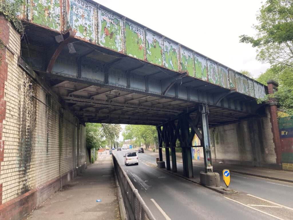
When the grandly-named Hull, Barnsley and West Riding Junction and Dock Railway Company opened its new line in 1885 part of it created a new physical city boundary. While railway bridges spanned existing routes such as Beverley Road, the raised embankment carrying the line effectively placed some developing suburbs inside a wall of earth.
Three decades later, the idea of extending Chanterlands Avenue and creating a new road under the railway line to ultimately connect with Cottingham Road started to take shape. Extensive subsequent negotiations between Hull Corporation and the line’s then owners North Eastern Railway eventually led to the construction of a new underpass road and the installation of a new bridge.
The lowered road opened to vehicles in late 1925 and a century later Chanterlands Avenue bridge is still there with its unusual design feature of a series of supporting columns which divides the carriageway below. Fifteen hours of solid rain a few months later caused the first flooding incident at the bridge with passengers in a taxi having to be rescued from the rising water. Flooding has been a problem ever since, including in 2007 when the road became impassable for several days unless you happened to own a canoe.
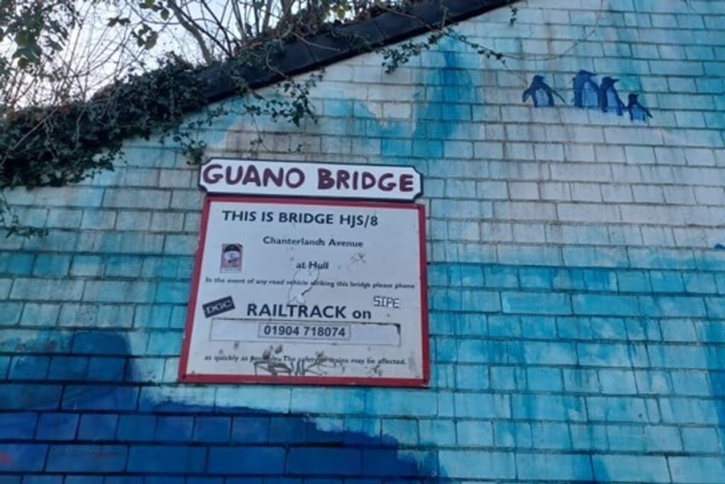
Another recurring issue has been the bridge’s appeal to nesting pigeons and the resulting mess they create. Anyone who has strolled along the raised walkways on either side of the road will know that avoiding stepping into some freshly-deposited guano is an everyday challenge. A few years ago some unknown local wit even decided to celebrate this by attaching a homemade sign unofficially re-naming the landmark as ‘Guano Bridge’.
Both the sign (now with a few missing letters) and the mess is still there but soon things could change on the cleanliness front. After several previous unsuccessful attempts to shift the pigeons involving netting and spikes, the city council has come up with a new plan. The initiative will see pots of bird-repellent gel being fixed to all of the bridge’s structure to scare the pigeons away. A typical gel mixture contains a colouring agent called pyranine. This fluoresces when triggered by UV radiation, causing the gel to glow with ultraviolet light. Invisible to the human eye, this light creates the impression of a burning fire to a bird which deters it from landing on nearby surfaces. In addition, the gel also contains peppermint oil – a long-standing bird repellent.
As a road closure is required while the gel pots are applied, it’s not going to be a cheap job to install them but the council hopes it will eventually save money currently being spent on cleaning up all the pigeon poo. A new council report says a budget of £18,534 has been set aside to close the road and carry out preparatory and cleaning work before buying and applying the gel pots.
The report adds: “Current bird proofing methods are not acting as a deterrent – the birds are building nests on top of the spikes currently installed and finding a way around them. The decision is a public health investment – by reducing exposure to guano, it could help reduce health impacts on vulnerable residents such as those with disabilities and those who are pregnant, particularly those with compromised immune systems. The decision improves living conditions – the environment will be cleaner, free from excessive bird droppings, which will improve the quality of life for those who live close to or pass by under the bridge regularly.”
Will it work? We shall see in a few months.

Our book correspondent Ally-mai looks at options for those who can’t get enough demigod action.

Artist Lucy Brooke, of the Feminine Urge Collective, runs down her most anticipated art shows of 2026.

We reckon even Sir Tom will have consigned his foray into the pop world to the bin. And he’s unlikely to thank our music misadventures correspondent Angus Young for fishing it back out.
At the height of Beatlemania, American music fans lapped up British pop bands. Among them was Herman’s Hermits, fronted by 17-year-old singer Peter Noone who had previously acted in Coronation Street. Their self-titled debut album was released in America in early 1965 and included both sides of the group’s first two UK singles and a song added at the last minute having been a regular fixture during live shows.
Mrs Brown, You’ve Got A Lovely Daughter wasn’t meant to be a single but that all changed when the track started to get heavy airplay by American radio DJs. The song entered the American Billboard Hot 100 chart at Number 12 and went on to spend three weeks at Number One.
Music writer Tom Breihan, whose book The Number Ones reviews every No. 1 chart hit in American history, describes the song as “an amiable and ambling little nothing.” He adds: “The song never archives lift-off. It never even tries for lift-off. Instead, it’s a morose little mutter, a self-pitying rock-kicker. In some small way it’s amazing that a song this flat and unassuming could have hit the way it did but that was the British invasion; lots of incredible music and lots of unremarkable music that people only only liked because it was British.”
Breihan suggests the song’s appeal might have been its easy-to-grasp storyline. “Noone is sad about being dumped, so he goes to the girl’s mother to assure her that he’s OK, even though he’s not particularly OK. It’s supposed to be a sort of stiff upper lip romantic gesture, even though it comes off more as trawling for sympathy.”
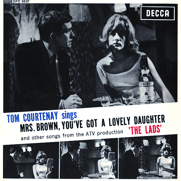
However, The Hermits weren’t the first to record the song, Two years earlier Hessle Road lad and lifelong Hull City fan Tom Courtenay had wrapped his tonsils around Mrs Brown, You’ve Got A Lovely Daughter on a single released by Decca. His version was first featured in a TV play called The Lads, in which he also starred. The play was set in a small town near a British army base in the Mediterranean and the plot concerned a group of soldiers led by Courtenay’s character going for a last night out looking for girls before their next deployment.
The song was one of four featured in the play and they were all written by fellow cast member Trevor Peacock, who later became best known for playing elderly eccentric Jim Trott in The Vicar of Dibley. To coincide with the broadcast, it was decided the Hull actor should record all four and release them as an EP on the Decca label with one being chosen as a single. A write-up on the reverse cover of the EP’s sleeve explains: “The songs form an integral part of the play’s plot and are, in the main, sung by different members of the cast; however on this record, we have Tom Courtenay’s own exciting versions.” Interestingly, he sings them all as his character in the play. As a result, his familiar gentle voice with an unmistakable Hull twang is replaced by an unfamiliar Cockney accent.
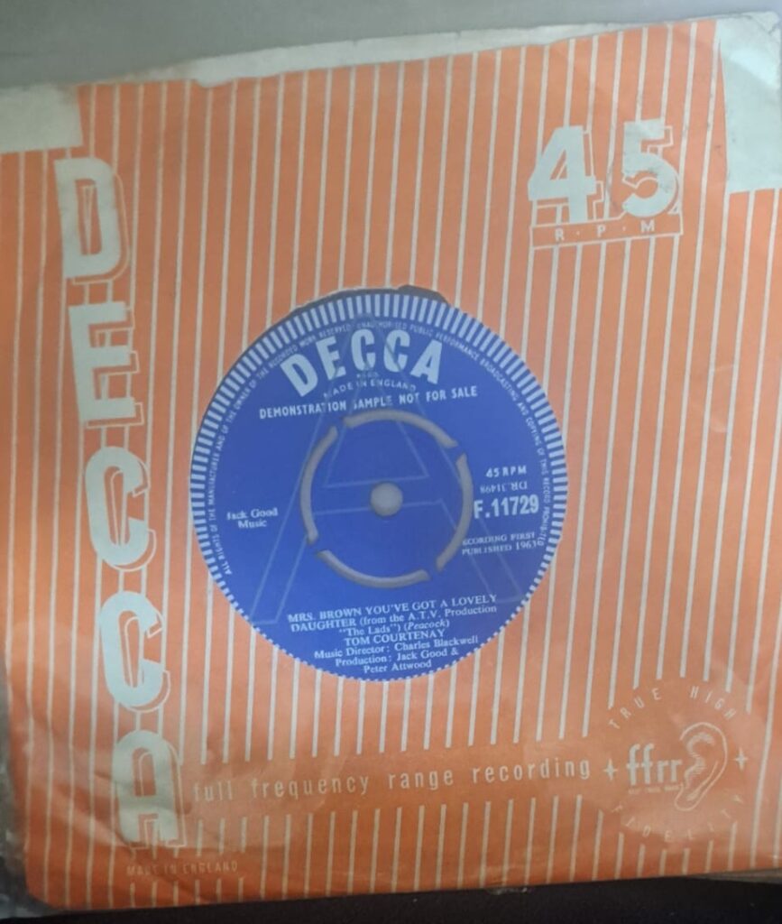
The single failed to make the charts, probably because Courtenay wasn’t keen on promoting it or becoming a pop star. “One thing I will not do, and that is sing on TV,” he said at the time. “It’s one thing to sing at a recording session but quite another to put a song over on TV. I’ve made an album of all the songs in the play and a single of Mrs Brown. I did it because I was in the play and I thought the songs were nice. I don’t think I’ll make any more records but you never know. Acting is really my only love. I have no desire to be a pop singer.”
It was a fair point, his breakthrough film Billy Liar had just been released and he was about to start work in a starring role in Dr Zhivago. (Listen to Sir Tom singing the song in the supplemental materials below – Ed.)
When The Hermits recorded the song, their producer Mickie Most fought hard against it being released as a single. He later described it as “probably the worst record ever made, or at least the worst I have been associated with.” Most’s lack of enthusiasm for the song probably explains why It was never released as a single in the UK but it eventually sold three million copies worldwide.
The song’s strange history would later include a cover version by the cartoon band Alvin and the Chipmunks and a 1967 instrumental-only version by Mexican band Elias and Ruiz and the Comanches.
However, Herman and the Hermits weren’t finished with it because it was used again as the title song for a 1968 feature film starring the band. Billed as a musical comedy, the script confusingly features two Mrs Browns – a greyhound inherited by Peter Noone who decides to enter it into a big money race to fund his struggling band’s dreams of becoming pop stars and also the mother of the girl he falls in love with along the way. Is there a happy ending? Sort of. The greyhound wins as Noone gets jilted but the film closes with him being consoled by another girl who lives nearby and who appears to have her heart set on making him her man. As the Swinging Sixties film poster says: “London is for the ‘birds’ and all the loveliest birds are flocking to Herman and his Hermits!”

Jade Wreathall, of HU7 Hive, has a soft spot for the painting on a shipping container in North Hull. And for good reason.