
Artist Zac Girdlestone tells us all about a unique textile and fashion society in Hull.
Artist Zac Girdlestone tells us all about a unique textile and fashion society in Hull.

It’s still there, looming over everything around but what, asks our voluminous artwork correspondent Angus Young, is next for Alan Boyson’s masterwork?

You might have noticed a bit of recent activity at the longest-running building site in Hull city centre. Final preparation work is now underway ahead of the demolition of the derelict former BHS and Co-op department stores. Once they have gone, the iconic Three Ships mosaic will be left in splendid if temporary isolation until the new mixed-use Albion Square development takes shape behind it.
The responsibility for delivering Albion Square was recently handed to Capital & Centric after the city council named the Manchester-based property and investment company as the project’s lead developer partner. A new planning application is expected to map out fresh design details for what is intended to be a mix of leisure, retail and residential space alongside the Three Ships. Hull’s biggest public artwork was saved from being bulldozed when a dedicated group of campaigners managed to convince the government to award it Grade II listed building status in 2019.
It was originally created in 1963 by the ceramic artist Alan Boyson as part of a major commission by the Hull and East Co-operative Society for its new flagship department store. It features almost one million pieces of coloured glass fixed onto a curved concrete screen depicting three stylised Hull trawlers.

As it happens, one of the main figures behind the campaign – Esther Johnson – is also responsible for a new exhibition celebrating Boyson’s life and work which opened recently. Titled ‘The Marvel From Marple’, it features material from their Ships In the Sky collection about the giant Hull mosaic, new multi-screen film exploring Boyson’s work and printed tiles, photographs and small Boyson ceramics from private collections.
The exhibition also includes the original architectural plans for the Merseyway car park in Boyson’s home town of Stockport. Esther said: “Growing up in Hull, gazing up at the scale and beauty of Alan Boyson’s Three Ships played a formative role in shaping my enthusiasm for mid-century design and my decision to study art. When I began researching Boyson’s work in 2017, I was particularly struck by the monumental concrete screens of Merseyway and his sophisticated use of modular abstraction and repetition.
“Both Three Ships and the Merseyway screens are deeply woven into the fabric of their respective civic centres, being symbols of geographical and historical local identity that embody the co-operative principle of uniting communities through art. I am delighted that this is the first exhibition to survey Boyson’s work and I hope it inspires a renewed and lasting appreciation of his remarkable talent.”
If you’re a Hull-based Boyson fan, the exhibition is a bit of a journey away as it’s being staged at the Stockroom venue in Stockport, Lancashire. It runs until September 30.
However, closer to home, the Three Ships is still going to be around to admire for decades to come while two other original Boyson works from the original Co-op commission have also been saved. A sponge-print tile mural previously installed in the fourth-floor Skyline Ballroom is now a feature in the new NHS Community Diagnostic Centre in Albion Street after being restored by a team of specialists. A third commission – a 22ft long shoal of 16 fish swimming through a sea of kelp made from stone and marble – has also been rescued and conserved for eventual display in the new development.
Angus Young

Quizmaster Ally-mai grabbed author Michelle Robinson at the recent Big Malarkey and put her through her general knowledge paces.

Chris is a leader at St. John’s Community Garden on Bransholme. He knows his onions. And his cabbages. And his etc…

In which three old men try to make connections between our home team and the current competition only to immediately descend into bickering and gibberish.

Nipping off work for an afternoon to watch the match became a joy thanks to the later Malcolm Scott, as our unapproved absence correspondent Phil Ascough reports.

Multi-talented Malcolm Scott is known as the man who built a successful commercial property business, tried to buy the Humber Bridge, and supported Hull’s arts and culture scene by launching Fruit Trade Music recording studio in Humber Street and Kardomah performance space in Alfred Gelder Street. What is often forgotten though is that in 1998 Mal also brought the World Cup to Hull. Sort of.
Having acquired Elsworth House – now the Humber Lofts building – as the new home for Scotts Chartered Surveyors, Mal decided to put the space to good use during the refurbishment period by opening it up for colleagues and contacts to watch matches from France 1998. You could call it “back of the net-working”.
After England opened their tournament with a 2–0 win over Tunisia, the front page of the Hull Daily Mail’s business section reported: “World Cup fever gripped the local business community as England kicked off their campaign. Offices were abandoned and pubs were packed as people rearranged their diaries to accommodate the big match. But one local firm saw the festival of football as the ideal opportunity to mix business with pleasure.”
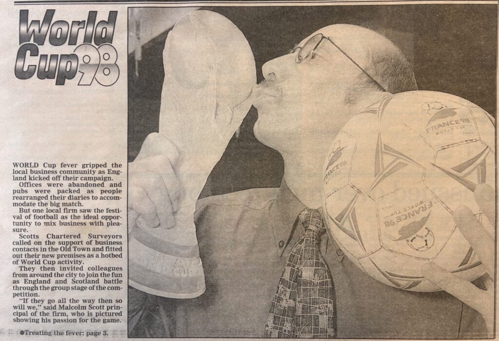
The article was accompanied by a picture of Mal holding a France 98 World Cup football and kissing a cardboard cutout of the trophy. On an inside page, I reported: “Never mind football coming home – this was football coming to work.”
Ever resourceful, Mal had borrowed eight TV sets from Fanthorpe’s in Hepworth’s Arcade. He also brought in two plastic dustbins, filled them with ice supplied by the Varsity pub – now Telstar 2 in Bowlalley Lane – and invited guests to bring their own refreshments. It was typical of Mal, who died in 2022, to introduce a community element by setting up some makeshift goalposts for a penalty challenge to raise funds for the Hull Task Force.
In addition to fun and fundraising, the football parties were a response to Mal’s resignation that the World Cup would just be too much of a distraction for workers across the city. He said: “We did this on the basis that little work is going to be done over the next couple of hours. The penalty shoot-out is the serious bit. The Task Force is trying to raise money to improve the central area of the city and this will help in a small way.”
The paper reported that “lawyers, bankers, accountants and others swelled the crowd to more than 60”. Neil Franklin, at the time a partner at Rollit, Farrell and Bladon and still a member of the team at Wilkin Chapman Rollits, said: “It’s a very important marketing opportunity and a chance to network with clients and business contacts.”
John Edmonds of Lloyds Bank said: “Something like this is typical of Malcolm Scott – and I say that as a compliment!” Peter Hadfield, Creative Director of Land of Green Ginger Design, said: “Our policy is that anyone can watch any of the matches any time they want as long as they make up the time if they need to, deadlines are met and services continue.” Ian Kelly, CEO of the Chamber of Commerce, advised: “It is always helpful to show flexibility when it comes to staff holidays – and moderation with beer and kebabs.”
The paper also published a “World Cup six-pack of big match excuses”.
1. Tube strike
2. Hamstring injury
3. Late call up to Hoddle’s squad
4. Nobody likely to call the office anyway
5. Sick relative – condition may worsen if England progress
6. Had to be there to write the story
Mal committed to matching England’s staying power throughout the tournament. He said: “If they go all the way then so will we.” But sadly England fell in the round of 16. In a match remembered for a red card for David Beckham, England lost to Argentina. On penalties.
Phil Ascough

Matt works at The Deep and he keeps penguins. He actually gets paid to look after penguins. And sometimes he feeds the sharks. How did he get so lucky?

Jade Wreathall loses herself in Orchard Park in order to meet the gang at a very popular place.

Our arboreal manuscription correspondent Angus Young outlines way for you to get involved in an exciting new tree-based storytelling project.
Here at Curiosity we love a question with the potential for multiple answers. It’s also something central to a new 18-month project being developed by Hull and East Riding Friends of the Earth called Tree Stories. The idea behind the project is a simple one – an open invitation to anyone in the region to tell a story about their favourite tree.
The story’s structure is entirely up to the person telling it. “You can respond in whatever way feels right,”explained local climate artist Lauren Saunders, who is co-designing and managing the project with Hull and East Riding Friends of the Earth. “There may be a tree that inspires you or calms you, or maybe you enjoy watching wildlife that lives in it. You may know of an unusual tree, a tree with an interesting story or folklore, a tree that is important to local wildlife or a tree planted in someone’s memory. Maybe it’s a story from your imagination or a tale that the tree itself might want to share. Whatever makes a particular tree special, we want to hear about it.”
All stories together with associated images and videos can be submitted via an online form available on the Hull and East Riding Friends of the earth website. (See supplemental materials, below.) From there, each story will be uploaded to a specially-curated Digital Forest on the website to create an interactive online archive of favourite local trees.
The Forest map aims to highlight where tree cover is low, where heat and flood risks are high and how air quality in some places could be improved. “By noticing, connecting and caring for the trees around us, we can protect what we have, plant more and help greener, cooler and more resilient neighbourhoods for everyone,” said Lauren.
To make the project as inclusive as possible, flyers giving information about it have been translated into Arabic, Kurdish, Polish and Romanian reflecting the four most common community languages spoken in the Hull area. If you’re not online, stories can be submitted by post to Tree Stories, Artlink, 87 Princes Avenue, Hull, HU5 3QP.
In addition, a programme of free events and activities to run alongside the project has also been launched. They will feature tips and advice on taking better care of existing trees and how to plant new ones as well as being able to explore the scientific secrets of trees and their importance to heritage and culture.
“We will also be promoting tree-related activities and events from our partners in the community to help people find amazing projects, initiatives and sites right on their door step,” said Lauren. “When we have Tree Story events to share, we will share them across our social media platforms and add them to our Digital Calendar on the Hull and East Riding Friends of the Earth website.”
As well as the project’s online presence, there will also be an emphasis on encouraging people to explore the trees around them whether at home, at school, in the workplace or in public parks and greenfield areas by creating their own activity or event. In addition, community and voluntary groups are being invited to run at least one tree-related activity between now and August 27, with support and mentoring being provided by Friends of the Earth.
To find out more about the project, the Tree Stories team will be manning a stall at the annual Roostock Festival at Rooted in Hull, St Peter Street, Hull city centre, on Saturday, June 20, from midday until 10pm.
Angus Young

The ever-popular Soap Box Derby returns to the Humber Bridge this weekend. Burnsy quizzes organiser Phil Withers for details.